Orange Risdon Family
Influence of the Orange Risdon Family Upon Saline and Other Towns
By Agnes L. Dikeman
Since numerous articles have been written about Orange Risdon and his accomplishments, this piece will speak only briefly on his mighty feats; instead, it will focus primarily on his wife and family. See the endnotes for sources of more information.
The first time I heard the unusual name, Orange Risdon, was prior to my moving to the Saline area. The Risdon home site was dedicated in 1954 and shortly after the occasion, I happened to visit the town. Salinians were greatly excited about the historic moment. At the time, I had not developed an interest in history and thought all the celebrating was much ado about nothing. However, one never knows where fate will lead. In later years my interest in history was much more solid. My husband and I moved to Lodi Twp., just outside Saline, and sometime later, I became active in the Saline Area Historical Society. It was then that I found myself more interested in Orange Risdon, the founding father of Saline.
Many ask how Orange Risdon got his name. In the 19th century, names came not only from family members, but sometimes from the places where family lived. Risdon ancestors had come from England and Orange might have been named after the English monarchy, the House of Orange. Or, perhaps there was a family connection to Orange County, VT. Also, in nearby New York State, there is a very important 17th century fort known as "Fort Orange" (now Albany). Wherever his name originated, Orange Risdon must have liked it because he named his own son, Orange, Jr. There are also some nephews who bear the name.
Orange Risdon, Surveyor
Orange Risdon came to Michigan Territory from the East. Born in Rupert, Bennington Co., Vermont on December 28, 1786, he was raised in Saratoga County in eastern New York State, where his parents Josiah and Martha Cochran Risdon had moved with their large family. Orange's formal common schooling ended when he was thirteen years old, but that is not to say that he was not well educated. He was tutored in navigation and surveying, with the goal of following the sea as a livelihood. As an apprentice, he studied surveying and carried the chain. Prior to his survey work in Michigan Territory, he worked at least one summer on a Great Lakes shipping vessel as a navigator. It wasn't long before his ability was recognized and he found his responsibilities and his wages were vastly increased. In 1807 at the age of 21, he was already a noted surveyor and his work was in demand. By then, he had attained the level of assistant surveyor and assessor.
In 1816 at the age of 30, he was well into his career when he married Sally Newland of Stillwater, Saratoga Co., New York, the daughter of Rial and Dorcas Newland. Sally's hometown of Stillwater played an important role in the Revolutionary War. It was the headquarters of Gen. Philip Schuyler and battles at this site became the "the turning point" in the war. Orange and Sally's first child Henry was born in Stillwater. (Sanders)
He then moved his young family to Genesee County in western New York, where he worked as a surveyor. They settled in the town of LeRoy, southwest of Rochester and east of Batavia. Several of his children were born there. It wasn't long before Risdon accumulated about 1000 acres of land on the Genesee River, an area where he had done extensive survey work. But shortly thereafter, the widespread financial crisis of 1817 occurred and his resources dwindled considerably. As did many men in 1823, he decided to go west to the Territory of Michigan. It was an opportunity waiting to happen, as land had to be surveyed before anyone could make a purchase. Risdon left New York State with survey tools in hand. (Collins)
Early Work in the Territory of Michigan
Now, the greatest of the Indian trails in the East and Midwest was the Sauk Trail, known by different names in various parts of its long route. This trail was actually transcontinental in scope, with the eastern end leading from the Atlantic seacoast to Fort Pitt (now Pittsburgh). New Englanders knew this part of the trail as Braddock's Road. The next portion known to white settlers was called the Great Trail or the Iroquois Trail. It led from Ft. Pitt, around the southern end of Lake Erie, across the Maumee River and north to Detroit. The great swamp between the Maumee and Detroit is noteworthy; its existence explains why the Territory of Michigan was known as the Black Swamp and settlement was slow in developing. The next portion was the Sauk Trail, from Detroit to the Chicago River. It is this portion that played such an important role in the life of Orange Risdon and subsequently, in the founding of Saline.
These were natural trails, the width of two warriors running side by side. They were dry and smooth during most times of the year. There were no large trees obstructing the way. Between villages, the trails were wide enough for the poles of a travois tied to a pony, the Indians' method of travel for hauling their belongings from one village to another. (Collins)
Once in Detroit, Risdon made the acquaintance of influential persons, such as Judge Samuel Dexter, Chief Justice of Washtenaw County, and Fr. Gabriel Richard, a delegate to Congress from the Michigan Territory. The influence of these men was beneficial to Mr. Risdon. Ever since the alliance of the English and the Indians during the War of 1812, the federal government believed there was an imperative need for a military road between Detroit and Chicago, in order that soldiers could move quickly should there be an Indian uprising. It was at this time that Fr. Gabriel Richard recommended Orange Risdon, an astute man with excellent credentials, for the job of chief surveyor of such a road. The federal government budgeted the grand sum of $3000 for the project.
In the beginning, Risdon intended to make the road as straight as possible between the two cities, but part way into the work, the government ran out of funds. As if that was not enough of a problem, there were some major obstacles such as heavy marshes, which caused him to follow the Sauk Trail, instead. This explains why today's US 12 is fairly straight from Detroit to Pittsfield Twp. But extending west from that point, it winds back and forth as a trail might have done. In subsequent decades, the road has had several names: the Military Road, the Chicago Turnpike, the Chicago Road, MI State Trunk Line #23, and US 112. Today, it is known as Michigan Ave. or US 12.
Washtenaw County had been established since 1822. While surveying the military road within the county, Orange Risdon decided he liked the Saline River Valley. The area was surrounded on all sides with beautiful countryside, capable of producing abundance in food and fuel. At the same time, water was available for manufacturing. Risdon purchased 164 acres in Saline Twp. in 1824 and an additional 78 acres in York Twp. the following year. (Peck) In prior decades, the Pottawatomie had a large village here and old timers often said the Indians never made a mistake in selecting a site for their village. It was a good spot, indeed.
Risdon produced a map in 1825, which contributed significantly to the settlement of Michigan Territory. The map was printed so that it could be folded and carried in a man's pocket, a convenience for anyone seeking to identify a property site. It was the first map to show in precise detail the lands available in the southeastern territory. Completion of the Erie Canal was imminent and Risdon had accurately predicted that the tide of immigration was just beginning. He ordered 472 copies to be printed. Today, two of the surviving thirteen copies are located in graduate libraries on the campus of the University of Michigan, Ann Arbor.
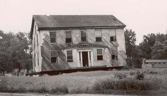
In 1829, Risdon chose a site for his house on the road he had surveyed and built it on the southeast hill overlooking the Saline River. This beautiful focal point and commanding spot is now part of Oakwood Cemetery. For many years, his house served as an inn, actually the first inn within the community. The year 1830 was extremely busy in the sense that Orange Risdon was an exuberant entrepreneur. The first election was held in his home in April. The first post office was in his house, with Risdon acting as the first postmaster for ten years. He rented out his parlor to Silas Finch, to be used as the first store. Risdon was the Justice of the Peace for twelve years. He founded the permanent village in 1832 and named it Saline, after the river of the same name.
Risdon built several rental houses within the village. In today's terms, he might be called a wheeler and dealer, establishing and maintaining several different businesses, including a livery business at the time when the railroad came through Saline. (The livery barn he built at one of his houses on the corner of Chicago Road and Lewis Street was constructed prior to 1834. It has been removed and restored at the Saline Railroad Depot Museum complex on N. Ann Arbor and Bennett Streets.) He continued working for the U.S. Government as a surveyor until 1856, surveying seventy-five townships and re-surveying forty-five others in Michigan. See.
Many years ago, a news reporter wrote that Orange Risdon has the distinction of being the only man living who took a prominent part in the laying of the corner stone of the first State Capitol in Detroit 50 years ago. "We think (he is) the most notable individual present (at the laying of the corner stone of the new State Capitol in Lansing) and one who attracted more attention than any one else. He is now 87 and he marched at the head of the Ann Arbor Commandory (Masons) at Lansing as nimble and spry as any man in that body. His health is good and he bids fair to live a number of years yet." (Ann Arbor Peninsular Courier)
Risdon's Washtenaw County Death Record confirms he died three years after that incident on November 26, 1876, at the age of 89 yrs., 10 mo., 30 days., after a short illness. It has been said he contracted a cold that he could not shake.
Since numerous articles have been written about Orange Risdon and his accomplishments, this piece will speak only briefly on his mighty feats; instead, it will focus primarily on his wife and family. See the endnotes for sources of more information.
The first time I heard the unusual name, Orange Risdon, was prior to my moving to the Saline area. The Risdon home site was dedicated in 1954 and shortly after the occasion, I happened to visit the town. Salinians were greatly excited about the historic moment. At the time, I had not developed an interest in history and thought all the celebrating was much ado about nothing. However, one never knows where fate will lead. In later years my interest in history was much more solid. My husband and I moved to Lodi Twp., just outside Saline, and sometime later, I became active in the Saline Area Historical Society. It was then that I found myself more interested in Orange Risdon, the founding father of Saline.
Many ask how Orange Risdon got his name. In the 19th century, names came not only from family members, but sometimes from the places where family lived. Risdon ancestors had come from England and Orange might have been named after the English monarchy, the House of Orange. Or, perhaps there was a family connection to Orange County, VT. Also, in nearby New York State, there is a very important 17th century fort known as "Fort Orange" (now Albany). Wherever his name originated, Orange Risdon must have liked it because he named his own son, Orange, Jr. There are also some nephews who bear the name.
Orange Risdon, Surveyor
Orange Risdon came to Michigan Territory from the East. Born in Rupert, Bennington Co., Vermont on December 28, 1786, he was raised in Saratoga County in eastern New York State, where his parents Josiah and Martha Cochran Risdon had moved with their large family. Orange's formal common schooling ended when he was thirteen years old, but that is not to say that he was not well educated. He was tutored in navigation and surveying, with the goal of following the sea as a livelihood. As an apprentice, he studied surveying and carried the chain. Prior to his survey work in Michigan Territory, he worked at least one summer on a Great Lakes shipping vessel as a navigator. It wasn't long before his ability was recognized and he found his responsibilities and his wages were vastly increased. In 1807 at the age of 21, he was already a noted surveyor and his work was in demand. By then, he had attained the level of assistant surveyor and assessor.
In 1816 at the age of 30, he was well into his career when he married Sally Newland of Stillwater, Saratoga Co., New York, the daughter of Rial and Dorcas Newland. Sally's hometown of Stillwater played an important role in the Revolutionary War. It was the headquarters of Gen. Philip Schuyler and battles at this site became the "the turning point" in the war. Orange and Sally's first child Henry was born in Stillwater. (Sanders)
He then moved his young family to Genesee County in western New York, where he worked as a surveyor. They settled in the town of LeRoy, southwest of Rochester and east of Batavia. Several of his children were born there. It wasn't long before Risdon accumulated about 1000 acres of land on the Genesee River, an area where he had done extensive survey work. But shortly thereafter, the widespread financial crisis of 1817 occurred and his resources dwindled considerably. As did many men in 1823, he decided to go west to the Territory of Michigan. It was an opportunity waiting to happen, as land had to be surveyed before anyone could make a purchase. Risdon left New York State with survey tools in hand. (Collins)
Early Work in the Territory of Michigan
Now, the greatest of the Indian trails in the East and Midwest was the Sauk Trail, known by different names in various parts of its long route. This trail was actually transcontinental in scope, with the eastern end leading from the Atlantic seacoast to Fort Pitt (now Pittsburgh). New Englanders knew this part of the trail as Braddock's Road. The next portion known to white settlers was called the Great Trail or the Iroquois Trail. It led from Ft. Pitt, around the southern end of Lake Erie, across the Maumee River and north to Detroit. The great swamp between the Maumee and Detroit is noteworthy; its existence explains why the Territory of Michigan was known as the Black Swamp and settlement was slow in developing. The next portion was the Sauk Trail, from Detroit to the Chicago River. It is this portion that played such an important role in the life of Orange Risdon and subsequently, in the founding of Saline.
These were natural trails, the width of two warriors running side by side. They were dry and smooth during most times of the year. There were no large trees obstructing the way. Between villages, the trails were wide enough for the poles of a travois tied to a pony, the Indians' method of travel for hauling their belongings from one village to another. (Collins)
Once in Detroit, Risdon made the acquaintance of influential persons, such as Judge Samuel Dexter, Chief Justice of Washtenaw County, and Fr. Gabriel Richard, a delegate to Congress from the Michigan Territory. The influence of these men was beneficial to Mr. Risdon. Ever since the alliance of the English and the Indians during the War of 1812, the federal government believed there was an imperative need for a military road between Detroit and Chicago, in order that soldiers could move quickly should there be an Indian uprising. It was at this time that Fr. Gabriel Richard recommended Orange Risdon, an astute man with excellent credentials, for the job of chief surveyor of such a road. The federal government budgeted the grand sum of $3000 for the project.
In the beginning, Risdon intended to make the road as straight as possible between the two cities, but part way into the work, the government ran out of funds. As if that was not enough of a problem, there were some major obstacles such as heavy marshes, which caused him to follow the Sauk Trail, instead. This explains why today's US 12 is fairly straight from Detroit to Pittsfield Twp. But extending west from that point, it winds back and forth as a trail might have done. In subsequent decades, the road has had several names: the Military Road, the Chicago Turnpike, the Chicago Road, MI State Trunk Line #23, and US 112. Today, it is known as Michigan Ave. or US 12.
Washtenaw County had been established since 1822. While surveying the military road within the county, Orange Risdon decided he liked the Saline River Valley. The area was surrounded on all sides with beautiful countryside, capable of producing abundance in food and fuel. At the same time, water was available for manufacturing. Risdon purchased 164 acres in Saline Twp. in 1824 and an additional 78 acres in York Twp. the following year. (Peck) In prior decades, the Pottawatomie had a large village here and old timers often said the Indians never made a mistake in selecting a site for their village. It was a good spot, indeed.
Risdon produced a map in 1825, which contributed significantly to the settlement of Michigan Territory. The map was printed so that it could be folded and carried in a man's pocket, a convenience for anyone seeking to identify a property site. It was the first map to show in precise detail the lands available in the southeastern territory. Completion of the Erie Canal was imminent and Risdon had accurately predicted that the tide of immigration was just beginning. He ordered 472 copies to be printed. Today, two of the surviving thirteen copies are located in graduate libraries on the campus of the University of Michigan, Ann Arbor.
In 1829, Risdon chose a site for his house on the road he had surveyed and built it on the southeast hill overlooking the Saline River. This beautiful focal point and commanding spot is now part of Oakwood Cemetery. For many years, his house served as an inn, actually the first inn within the community. The year 1830 was extremely busy in the sense that Orange Risdon was an exuberant entrepreneur. The first election was held in his home in April. The first post office was in his house, with Risdon acting as the first postmaster for ten years. He rented out his parlor to Silas Finch, to be used as the first store. Risdon was the Justice of the Peace for twelve years. He founded the permanent village in 1832 and named it Saline, after the river of the same name.
Risdon built several rental houses within the village. In today's terms, he might be called a wheeler and dealer, establishing and maintaining several different businesses, including a livery business at the time when the railroad came through Saline. (The livery barn he built at one of his houses on the corner of Chicago Road and Lewis Street was constructed prior to 1834. It has been removed and restored at the Saline Railroad Depot Museum complex on N. Ann Arbor and Bennett Streets.) He continued working for the U.S. Government as a surveyor until 1856, surveying seventy-five townships and re-surveying forty-five others in Michigan. See.
Many years ago, a news reporter wrote that Orange Risdon has the distinction of being the only man living who took a prominent part in the laying of the corner stone of the first State Capitol in Detroit 50 years ago. "We think (he is) the most notable individual present (at the laying of the corner stone of the new State Capitol in Lansing) and one who attracted more attention than any one else. He is now 87 and he marched at the head of the Ann Arbor Commandory (Masons) at Lansing as nimble and spry as any man in that body. His health is good and he bids fair to live a number of years yet." (Ann Arbor Peninsular Courier)
Risdon's Washtenaw County Death Record confirms he died three years after that incident on November 26, 1876, at the age of 89 yrs., 10 mo., 30 days., after a short illness. It has been said he contracted a cold that he could not shake.
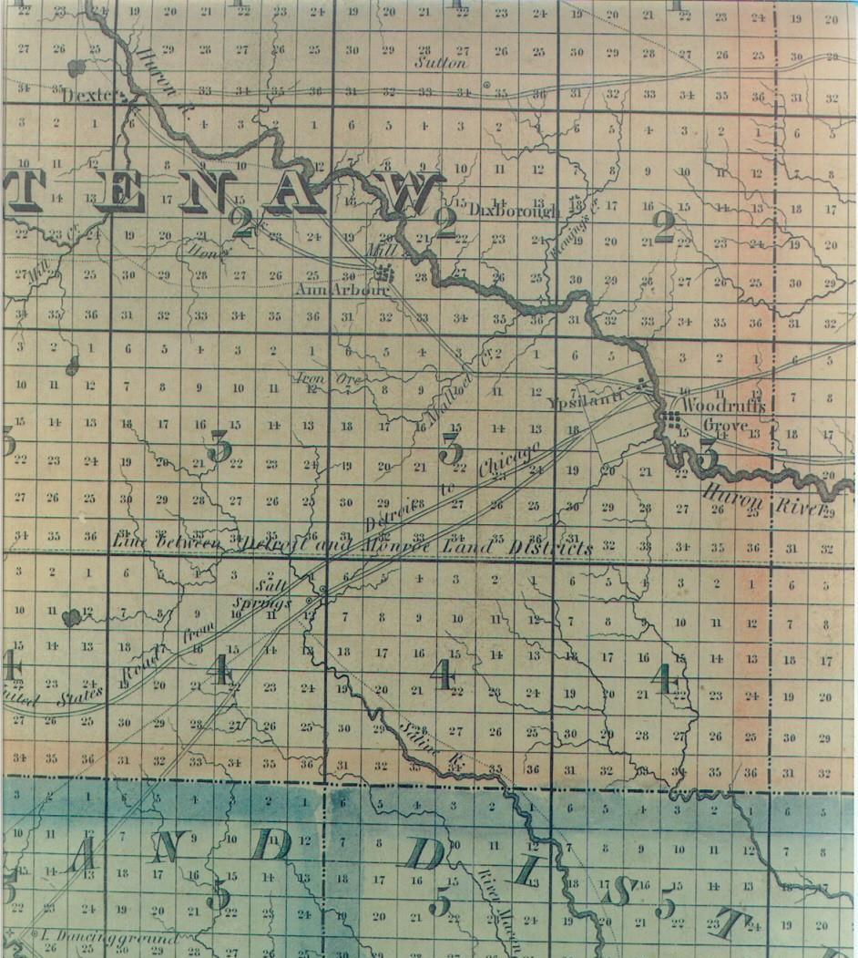
Orange Risdon's Map 1825
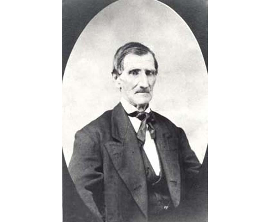
Orange Risdon
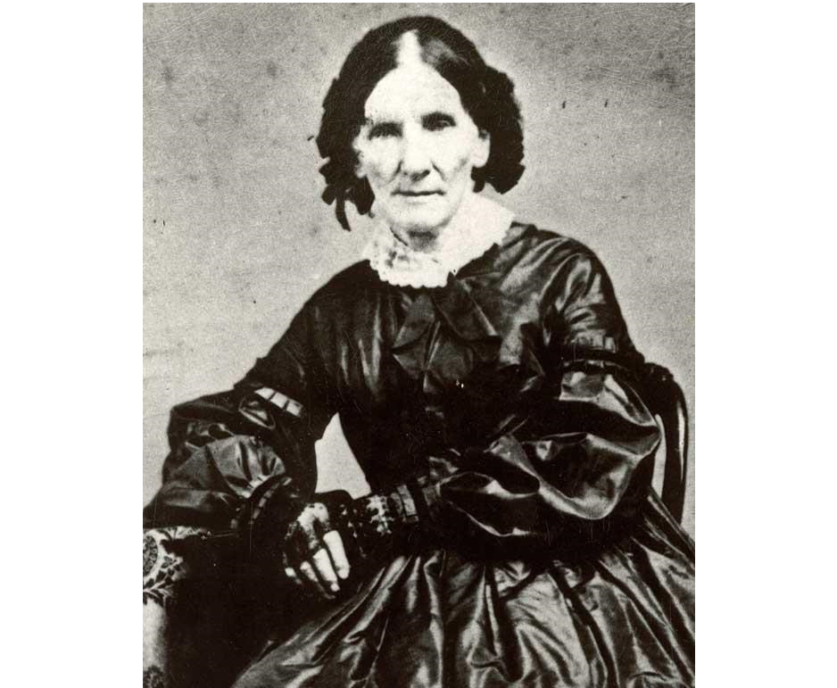
Sally Risdon
Silas Mead Family
Moving Risdon House
Risdon Factory
Sally Risdon: Wife and Mother
Sally Risdon is the daughter of Rial (a.k.a.Royal) Newland and Dorcas Irish. Rial was a very prosperous businessman in Stillwater, NY. He was a wagoner in the Continental Army during the Battles of Saratoga, which took place in the Town of Stillwater. Afterward, he owned part of the battlefield and was a mill owner in the village. He was a prominent member of the Baptist Church and there is a window dedicated to his family in the church. This church is still in existence as the Stillwater United Church, Presbyterian.
"Sally's mother was quite possibly the daughter of Rev. David Irish, the local Baptist minister. Sally is the ninth child of eleven. Rial had a sister named Abigail who was married to Rev. Lemuel Powers. Their youngest daughter, also named Abigail, grew up to marry Millard Fillmore, our famous thirteenth President."(Sanders)
Orange and Sally Risdon had seven children, six boys and one girl. Only one child, Allen H., was born in Saline. The others were born between 1817 and 1824 in New York State. Sally Risdon had remained in LeRoy, NY during the years her husband traveled on foot and horseback all over the Territory of Michigan. The booklet entitled Founder's Week reprinted letters (originals at the Clements Library, UM Campus) exchanged in 1825, between the distraught wife and the hardworking husband. Sally complains that she and the children are lonely. Orange promises to come home soon, but the weeks turn into months and fall turns into spring, year after year. The weather and other obstructions are greater than anticipated. He and his men endure hardships like they had not imagined. Orange responds that the mail is slow. Little Harriett cries herself to sleep. (Clements)
Some time prior to the fall of 1832, Sally arrived in Saline. We do not know if Orange traveled to LeRoy to bring his family to Michigan or whether Sally made the trip with the six children all by herself. At any rate, Allen Hutchins Risdon was born in Saline on October 7, 1832 (documented in burial record). It is not difficult to imagine Sally Risdon raising the children almost single-handedly, with her husband spending most of his time "out in the field".
Shortly before the Risdons' 50th wedding anniversary, Sally Newland Risdon died Oct. 19, 1866 at the age of 76 yrs. 9 mo. 22 dys. Both she and Orange are buried in Oakwood Cemetery, Saline. (burial record)
Children of Orange and Sally Risdon
The oldest boy was Henry N. He was born October 1817 in Stillwater, NY, his mother's hometown. In due time, Henry married Matilda Smith, who was also from Stillwater. In 1836, he purchased 40 acres in Sec. 30 of Freedom Twp., in Washtenaw Co. (Peck) A few years later, he purchased Orange and Sally Risdon's share of Sally's parents' property in Stillwater, NY; the deed is dated Dec. 20, 1839. After Henry's death in 1844 at the age of 25 years, Matilda went to live with her parents, the Smiths. In the 1850 Census of Stillwater, NY, she is listed as living with them. Both Henry and Matilda are buried in the Stillwater Union Cemetery. There are no known children.
Robert M. Risdon was born January 30, 1819 in LeRoy, NY; died Jan. 1, 1873 in Manistee, MI; married to Cornelia ----. Robert was still in Saline in the 1845 Census (Capers); he later moved to Manistee, where he lived at a time when the entire county was populated with less than 1000 people. In the 1860 County Census, he was 40 years old, a surveyor, with $5000 in real estate.
As a surveyor, he was later instrumental in developing the Manistee River Improvement Co. He was one of six founding members, whose primarily goal was to relieve the obstructions of ancient log jams, thereby improving the opportunities to market lumber from the headwaters of the Manistee. The History of Manistee Co. documents information that shows it had been impossible to move this lumber prior to 1870.
In 1873, three years after beginning this momentous work, Robert Risdon died. His probate file #154 states he had a typed will and no children. His wife Cornelia (whose maiden name is not known at this writing) was one of two executors. The year Robert died, there was a total of only nine deaths in the entire county.
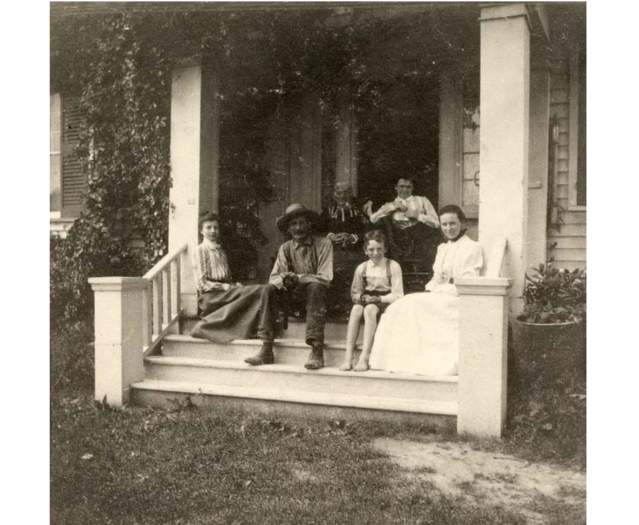
Harriett Risdon was born Sept 21, 1821 in LeRoy, NY and died 1903 at Saline. She had married Silas Mead in 1840. Silas was born March 17, 1812 in Greenwich, CT and was a nephew of Silas Finch, who operated a general store in Orange Risdon's parlor. Silas Mead clerked for his uncle at one time. Both Harriett and Silas are buried in Oakwood Cemetery, Saline. (Clark)
Silas and Harriett had a farm in Pittsfield Twp., where they lived for the first eleven years of their marriage.
They then removed to New Orleans, LA, where Silas operated a shoe store. During the Civil War, he made oil-cloths for soldiers' sacks; after the Union Soldiers took the city, he worked in the New Orleans Commissary Dept. for 4 years.
Then, he came back to Washtenaw and farmed until his death. A letter that he sent to his sister Abigail in CT is archived at the Bentley Library in Ann Arbor. This letter has been transcribed and appears in Vol. 10 of Capers, the journal of the Genealogical Society of Washtenaw County.
Harriett and Silas had four children. One son, Lewis Risdon Mead, figured highly in the family businesses that thrived in California. More on that later. Their son, William, lived in the Risdon homestead until 1921, after which the house became the property of Blanche Charlotte Mead, William's daughter.
Later, the home was sold to a Saline nephew, Capt. William D. Mead, who moved the house to W. Henry Street, where it is still in use today as apartments. Blanche was present when the Historical Society of Washtenaw County dedicated her great grandfather's home site in 1954. A memorial sign was erected at the time, but has since deteriorated.
During his lifetime, Orange Risdon, Sr. allowed people to be buried on his farm. Thus, the burial grounds were started and later continued when William D. Mead sold 50 acres to the Village of Saline to enlarge the cemetery.
John Nelson Risdon was born July 10, 1822 in LeRoy, NY and died August 1877 in Oakland, CA. He was married to Elizabeth McCarty. "They had one child, who is living in San Francisco (in 1914)", according to Daniel B. Risdon, family historian. (Risdon & Cook)
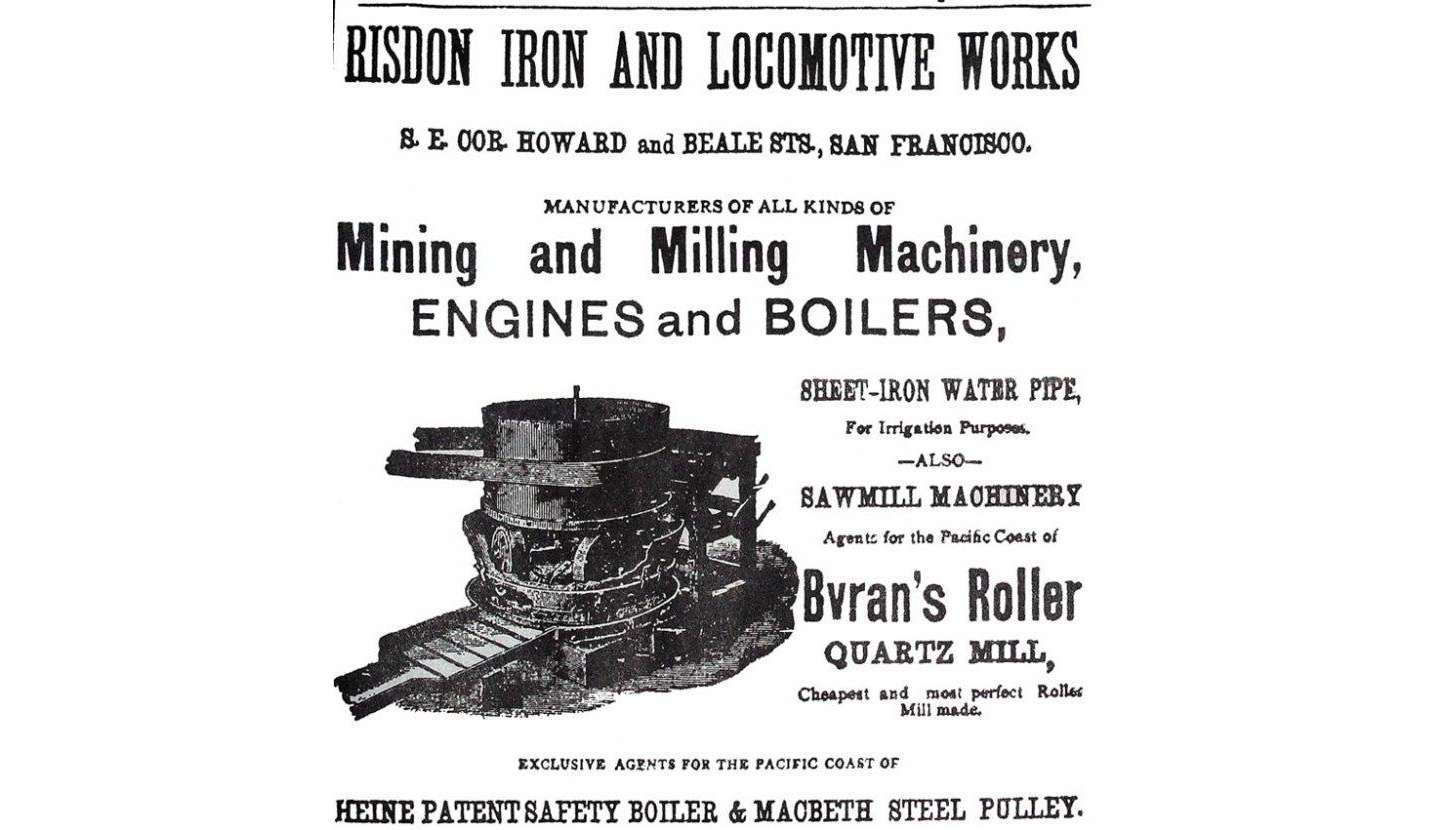
John Nelson and Orange, Jr. appear in California at the heart of the gold rush, as one of many tradesmen working as blacksmiths, iron mongers, and machinery makers. Carol Jensen of E. Contra Costa County Historical Society, Brentwood, CA has written extensively on the accomplishments of these two men and has kindly given permission to quote from her article, The Risdon Boys Go West. (Jensen)
John and Orange, Jr. worked as blacksmiths and boilermakers under several business names. I was fortunate to find one of their ads, which appeared in a reprint of an 1881 Tombstone Epitaph. It is included here, with the permission of the present-day editor Dean Prichard.
Lewis Cass Risdon was born April 25, 1824 in LeRoy, NY and died March 15, 1887 in Ann Arbor, MI. He was married to Gertrude Betsy Judd January 7, 1851 in Albion, MI. She was born August 22, 1830 in Milo, NY and died Jan. 19, 1877.
In the permanent holdings of the Washtenaw County Historical Society is a black-painted Windsor high chair. Though some had thought this to be Orange Risdon's high chair, others believed that to be highly unlikely. The chair is on display at the Museum on Main Street, in Ann Arbor. The curator of WCHS, Judith Chrisman, has done extensive research and contends that this chair came to Michigan with the Judd Family in 1837 and was passed down within the family, until it came into the possession of Lewis Cass and Betsy Judd Risdon. It was donated to WCHS by a descendant of the Risdon Family. (Chrisman)
Lewis was the Treasurer and Tax Collector for Ann Arbor Twp. He was also prominent in the hardware business in Ann Arbor. He and his wife Betsy had five children, but only two were living at the time he wrote his will, which was probated in Washtenaw County. He left:1/3 of his property to his daughter, Carrie R. (Mrs. Edward) Hinman. He left $100 to his 2nd wife Alice M. to buy some keepsake, by which she would remember Lewis (Alice, having other properties of her own)." He left his dau. Isadore M. (Mrs. Pierce) Ryan: the use of the remainder of his properties, which would then go to his grandsons after Isadore's death." The reasons Lewis stated for doing this left the reader with indications that Lewis was highly suspicious of his son-in-law's intentions.
Orange Risdon, Jr. was born June 26, 1827 in LeRoy, NY and died 1865 in San Francisco, CA. He was in San Francisco by 1860, when the City Directory identified him as a boilermaker. At a later date, he was a bookkeeper for the Risdon Iron Works. He and his brother, John N., improved property containing salt springs, about 65 miles west of San Francisco. "The Saline Salt Mfg. and Mining Co. was incorporated in 1863, but the endeavor ended before it actually began as the plan was not economically feasible. Shipping the product was much too difficult. The property continued as an informal spa and watering hole, as it had been since the days of the Mountain Men. A land patent was filed for 160 acres with the salt springs at the center." (Jensen)
In 1865, Orange Jr. died unexpectedly on a trip to San Louis Obispo, CA. A probate record (intestate) reveals his brother Lewis Cass was appointed administrator of the Washtenaw Co. estate and he gave a statement that his brother "left no widow or children, as he never married".
His California estate, as well as his Michigan estate, went to his father, Orange, Sr. who was still residing in Michigan. Probate Record #2301, dated 1866 indicates that Orange, Jr. had property within the Village of Saline. It was "the length of 20 rods along the south side of the Chicago Road and the width of 8 rods along the east side Harrison (sic) Street (and the same on parallel sides) in the NE: Sec. 1, T4 R5E." Among numerous papers was one written in the hand of, and signed by the senior Orange, who, having paid off his son's notes, filed a claim in the amount of $1106.90 for such on June 3, 1867.
The last child, Allen Hutchins Risdon, was born October 7, 1832 in Saline, MI. His obituary, published July 30, 1896 in the Dakota Huronite, Huron, SD., states he died July 24, 1896. Allen had married twice. His first wife was Emily J. Root, whom he married in Saline, 1855. Allen and Emily had one son George B. Risdon, who was born 1856, probably in Saline. Emily died in 1860 at the age of 26 and is buried in Oakwood Cemetery, Saline.
Allen was in Saline when he wrote a letter that was discovered in June of 1987 in a time capsule in the Burkhardt Building. The letter was one of several paper items concealed in a copper tube and found when renovations took place in the building. Risdon's message was written and dated on his letterhead stationery. Here, it is transcribed verbatim:
"Saline Michigan, July 12th 1872
To Whom It May Concern: This box and its contents were deposited in this nitch (sic) on the date above written. This building, two stores, was erected in the year of our lord Eighteen hundred and Seventy two by Allen H. Risdon and Charles Burkhart & Edgar R. Aldrich.
"The first named built the west one and the latter the east one. The Rival Candidates for Presidency are U.S. Grant & Horace Greely (sic). This year the fourth Trans Atlantic Cable is about to be laid. The North (sic) & Southern Pacific R.R. are being pushed through with energy. Chicago is being rapidly rebuilt, and Woman's rights are just beginning to attract attention" (Signed) Allen H. Risdon, The Father of A.H. Risdon (who) settled this town (and) is now 86 years of age and hale and hearty."
Like his father, Allen networked with persons of special talent. He became a good friend of the soon-to-be-famous western photographer, Frank Jay Haynes, also born in Saline, but 20 years Allen's junior. By 1874, Allen owned Risdon's Western Art Gallery. Jay Haynes worked as his assistant, first in Michigan, then Chicago and Milwaukee. They operated an itinerant sales wagon selling chromolithographs and sundry items related to music. (Montana H.S.) By 1875, Risdon was in Minneapolis.
One of Allen's cousins, Almira Newland, became his second wife. Almira was born in Stillwater, NY. They were married June 4, 1877 in Hudson, WI. Much later, they were buried in Riverside Cemetery, Huron, Beadle Co., S.D. His only son George is listed in Allen's obituary and he, too, is buried in Riverside. (Hickle)
Grandson of Orange and Sally Risdon
Lewis Risdon Mead, a grandson of Orange Risdon, Sr., was born Sept. 7, 1847 in Saline and died June 12, 1916 in San Francisco. He is particularly worth mentioning because of his role in expanding the California property that had originally been acquired by the brothers, John and Orange.
He was living with his parents in New Orleans when he left for California at the age of 18 years. This would have been near the end of the Civil War in 1864. He sailed via the Isthmus of Panama. Shortly after he arrived in California, President Andrew Johnson signed and granted the salt springs property to Orange, Jr.
At first, Lewis R. Mead worked in his uncles' California Iron Works, but he also helped his Uncle Orange develop the acreage at the salt springs. There was a real threat from squatters and the property had to be protected. Unfortunately in 1865, within a year after Lewis Risdon had arrived, Orange, Jr. died unexpectedly.
Even though he was still a very young man, Lewis Risdon Mead was the administrator of his Uncle Orange's estate; Orange had died intestate, meaning he died without a will, so his property went to his father. This is a very important milestone in the success of the Risdon Boys' California property. It led to a turn of events which caused disagreement within the Risdon family, as John contended both he and Orange Jr. purchased the salt springs property. After the death of his father in 1876, John Nelson contested the 1865 papers concerning the property purchase. John Nelson argued Orange, Jr. was acting for both brothers, but after a four year battle, the courts settled in favor of Lewis Mead, who had purchased the property that had gone to his grandfather Orange, Sr. The court settlement led to the development of the salt springs. This can only be thought of as good business because in due time, the springs became a world famous health resort, eventually known as Byron Hot Springs. (Jensen)
Mead married Blanche Durant ca. 1873 in Oakland, CA. She was born 1855 in Canada. Mead continued to improve the salt springs property, eventually building three different hotels, replacing one after another due to fires. In 1908, he married Mae Sadler. He lived another eight years before his own death from bronchial pneumonia in 1916. Mae Sadler managed the property, continuing to make improvements. Four years later, Mae Sadler Mead remarried to architect, James Reid, who had designed the hotel at the spa. Byron Hot Springs turned into a resort for Hollywood stars and San Francisco socialites. However, the Depression Years took its toll on the enterprise, leading to its decline. For a while during World War II, the federal government used the property as an interment camp for prisoners. By 1946, it was deeded to the Greek Orthodox Church to be used as a mission camp. After that, there were several different owners and different enterprises. (Jensen)
All in all, the seven children of Orange and Sally Risdon led interesting, enterprising, and successful lives. Each of their children lived well into adulthood; six of the seven married and four produced grandchildren. At a time in history when one was considered to have lived a full life at age 60, daughter Harriett lived to be 82 and Allen lived to be 64. Orange, Sr. himself, lived to be one month short of 90 years old. It is quite likely Sally Newland Risdon lived to be 80. It can be said that the family genes come from good stock!
To Conclude:
The Saline Area Historical Society holds many files (though no primary documents) relating to Orange Risdon, Sr., his survey work, his local and statewide endeavors, and his children. Much has been written about this talented, incredible man. His surveys within Michigan covered much of the state; he held unknown numbers of local positions including that of founder of the Village of Saline in 1832. At various times, Risdon had several different businesses in Saline including that of selling and renting properties. He was a Mason since 1810 at age 24, and "each year thereafter, he advanced in degree. He continued working as a government surveyor until 1856. His maps influenced settlers coming to Michigan. He was often consulted for advice and was generous in giving land for schools and churches. At the time of his death, he had held the Knight's Templar degree longer than any man in the U.S. He was a true pioneer, generous in spirit, and helpful to all who came at a later date. He had a large funeral, with many mourners having come from various out-of-town places." (Chapman)
For additional information, visit the William L. Clements Library and the Bentley Historical Library in Ann Arbor or contact the Saline Area Historical Society.
Bibliography
Ann Arbor Peninsular Courier, Oct. 19, 1873
1860 Census of Manistee County, transcribed on www.rootsweb.com, p. 11-20.
Chapman, Chas. C., History of Washtenaw County, publ. 1881, Chas. C. Chapman Co., Chicago.
Chrisman, Judith, The Risdon Chair quoted in Washtenaw Impressions, Sept./Oct. 2004.
Clark, Ella M., Burials in Oakwood Cemetery, Village of Saline, Washtenaw Co., self published 1958.
Clements, Wayne et al, Founder's Week publ. by Saline Area Historical Society, 2001.
Collins, Bessie Carven, Saline Founding by Orange Risdon, 1824 Anniversary Marked, publ. in Saline Observer, 1883.
Genealogical Society of Washtenaw County, Capers, Volume 7 and 10.
Hickle, Sheryl Stearns, Ass't Beadle Co. Coordinator of U.S. GenWeb site; correspondence with Robert W. Lane of SAHS. Used with permission.
History of Manistee Co., MI, publ. by H.R. Page & Co., 1882.
Jensen, Carol A., The Risdon Boys Go West, publ. by E. Contra Costa (CA) Historical Society, 2000.
Lane, Robert W., Saline Salt Springs on this website.
Manistee Co., MI Probate Records: FHL Film #945573, #154 Robert Risdon.
Montana Historical Society, F. Jay Haynes, Photographer, publ. 1981.
Oakwood Cemetery Records: Records for various Risdon Family members.
Obituary of Allen Hutchins Risdon, publ. in Dakota Huronite, Huron, S.D., July 30, 1896
Peck, Paul R., Landsmen of Washtenaw County, published privately, 1986.
Pittsfield Twp. Historical Society, image of 1825 Risdon map.
Probate Records, Washtenaw County: #5497 Lewis C. Risdon, #2301 Orange Risdon, Jr.
Risdon, Allen H.; correspondence dated July 12, 1872, found in Saline time capsule in 1987; on display at the Depot Museum.
Risdon, Daniel B. and Cook, Robert E., Descendants of Josiah Risdon and Martha Cochran, self published 1982.
Sanders, Linda, Town and Village Historian, Stillwater, NY; correspondence Nov. 10, 2004.
Sylvester, Nathaniel Bartlett, History of Saratoga Co., NY, 1878.
Washtenaw Co. Death Records, FHL Film # 1019062, # 263 Orange Risdon.
Washtenaw County Historical Society, Ann Arbor, MI,Washtenaw Impressions, June 1955.
Acknowledgements
With sincere gratitude, my thanks goes out to:
Sally Risdon is the daughter of Rial (a.k.a.Royal) Newland and Dorcas Irish. Rial was a very prosperous businessman in Stillwater, NY. He was a wagoner in the Continental Army during the Battles of Saratoga, which took place in the Town of Stillwater. Afterward, he owned part of the battlefield and was a mill owner in the village. He was a prominent member of the Baptist Church and there is a window dedicated to his family in the church. This church is still in existence as the Stillwater United Church, Presbyterian.
"Sally's mother was quite possibly the daughter of Rev. David Irish, the local Baptist minister. Sally is the ninth child of eleven. Rial had a sister named Abigail who was married to Rev. Lemuel Powers. Their youngest daughter, also named Abigail, grew up to marry Millard Fillmore, our famous thirteenth President."(Sanders)
Orange and Sally Risdon had seven children, six boys and one girl. Only one child, Allen H., was born in Saline. The others were born between 1817 and 1824 in New York State. Sally Risdon had remained in LeRoy, NY during the years her husband traveled on foot and horseback all over the Territory of Michigan. The booklet entitled Founder's Week reprinted letters (originals at the Clements Library, UM Campus) exchanged in 1825, between the distraught wife and the hardworking husband. Sally complains that she and the children are lonely. Orange promises to come home soon, but the weeks turn into months and fall turns into spring, year after year. The weather and other obstructions are greater than anticipated. He and his men endure hardships like they had not imagined. Orange responds that the mail is slow. Little Harriett cries herself to sleep. (Clements)
Some time prior to the fall of 1832, Sally arrived in Saline. We do not know if Orange traveled to LeRoy to bring his family to Michigan or whether Sally made the trip with the six children all by herself. At any rate, Allen Hutchins Risdon was born in Saline on October 7, 1832 (documented in burial record). It is not difficult to imagine Sally Risdon raising the children almost single-handedly, with her husband spending most of his time "out in the field".
Shortly before the Risdons' 50th wedding anniversary, Sally Newland Risdon died Oct. 19, 1866 at the age of 76 yrs. 9 mo. 22 dys. Both she and Orange are buried in Oakwood Cemetery, Saline. (burial record)
Children of Orange and Sally Risdon
The oldest boy was Henry N. He was born October 1817 in Stillwater, NY, his mother's hometown. In due time, Henry married Matilda Smith, who was also from Stillwater. In 1836, he purchased 40 acres in Sec. 30 of Freedom Twp., in Washtenaw Co. (Peck) A few years later, he purchased Orange and Sally Risdon's share of Sally's parents' property in Stillwater, NY; the deed is dated Dec. 20, 1839. After Henry's death in 1844 at the age of 25 years, Matilda went to live with her parents, the Smiths. In the 1850 Census of Stillwater, NY, she is listed as living with them. Both Henry and Matilda are buried in the Stillwater Union Cemetery. There are no known children.
Robert M. Risdon was born January 30, 1819 in LeRoy, NY; died Jan. 1, 1873 in Manistee, MI; married to Cornelia ----. Robert was still in Saline in the 1845 Census (Capers); he later moved to Manistee, where he lived at a time when the entire county was populated with less than 1000 people. In the 1860 County Census, he was 40 years old, a surveyor, with $5000 in real estate.
As a surveyor, he was later instrumental in developing the Manistee River Improvement Co. He was one of six founding members, whose primarily goal was to relieve the obstructions of ancient log jams, thereby improving the opportunities to market lumber from the headwaters of the Manistee. The History of Manistee Co. documents information that shows it had been impossible to move this lumber prior to 1870.
In 1873, three years after beginning this momentous work, Robert Risdon died. His probate file #154 states he had a typed will and no children. His wife Cornelia (whose maiden name is not known at this writing) was one of two executors. The year Robert died, there was a total of only nine deaths in the entire county.
Harriett Risdon was born Sept 21, 1821 in LeRoy, NY and died 1903 at Saline. She had married Silas Mead in 1840. Silas was born March 17, 1812 in Greenwich, CT and was a nephew of Silas Finch, who operated a general store in Orange Risdon's parlor. Silas Mead clerked for his uncle at one time. Both Harriett and Silas are buried in Oakwood Cemetery, Saline. (Clark)
Silas and Harriett had a farm in Pittsfield Twp., where they lived for the first eleven years of their marriage.
They then removed to New Orleans, LA, where Silas operated a shoe store. During the Civil War, he made oil-cloths for soldiers' sacks; after the Union Soldiers took the city, he worked in the New Orleans Commissary Dept. for 4 years.
Then, he came back to Washtenaw and farmed until his death. A letter that he sent to his sister Abigail in CT is archived at the Bentley Library in Ann Arbor. This letter has been transcribed and appears in Vol. 10 of Capers, the journal of the Genealogical Society of Washtenaw County.
Harriett and Silas had four children. One son, Lewis Risdon Mead, figured highly in the family businesses that thrived in California. More on that later. Their son, William, lived in the Risdon homestead until 1921, after which the house became the property of Blanche Charlotte Mead, William's daughter.
Later, the home was sold to a Saline nephew, Capt. William D. Mead, who moved the house to W. Henry Street, where it is still in use today as apartments. Blanche was present when the Historical Society of Washtenaw County dedicated her great grandfather's home site in 1954. A memorial sign was erected at the time, but has since deteriorated.
During his lifetime, Orange Risdon, Sr. allowed people to be buried on his farm. Thus, the burial grounds were started and later continued when William D. Mead sold 50 acres to the Village of Saline to enlarge the cemetery.
John Nelson Risdon was born July 10, 1822 in LeRoy, NY and died August 1877 in Oakland, CA. He was married to Elizabeth McCarty. "They had one child, who is living in San Francisco (in 1914)", according to Daniel B. Risdon, family historian. (Risdon & Cook)
John Nelson and Orange, Jr. appear in California at the heart of the gold rush, as one of many tradesmen working as blacksmiths, iron mongers, and machinery makers. Carol Jensen of E. Contra Costa County Historical Society, Brentwood, CA has written extensively on the accomplishments of these two men and has kindly given permission to quote from her article, The Risdon Boys Go West. (Jensen)
John and Orange, Jr. worked as blacksmiths and boilermakers under several business names. I was fortunate to find one of their ads, which appeared in a reprint of an 1881 Tombstone Epitaph. It is included here, with the permission of the present-day editor Dean Prichard.
Lewis Cass Risdon was born April 25, 1824 in LeRoy, NY and died March 15, 1887 in Ann Arbor, MI. He was married to Gertrude Betsy Judd January 7, 1851 in Albion, MI. She was born August 22, 1830 in Milo, NY and died Jan. 19, 1877.
In the permanent holdings of the Washtenaw County Historical Society is a black-painted Windsor high chair. Though some had thought this to be Orange Risdon's high chair, others believed that to be highly unlikely. The chair is on display at the Museum on Main Street, in Ann Arbor. The curator of WCHS, Judith Chrisman, has done extensive research and contends that this chair came to Michigan with the Judd Family in 1837 and was passed down within the family, until it came into the possession of Lewis Cass and Betsy Judd Risdon. It was donated to WCHS by a descendant of the Risdon Family. (Chrisman)
Lewis was the Treasurer and Tax Collector for Ann Arbor Twp. He was also prominent in the hardware business in Ann Arbor. He and his wife Betsy had five children, but only two were living at the time he wrote his will, which was probated in Washtenaw County. He left:1/3 of his property to his daughter, Carrie R. (Mrs. Edward) Hinman. He left $100 to his 2nd wife Alice M. to buy some keepsake, by which she would remember Lewis (Alice, having other properties of her own)." He left his dau. Isadore M. (Mrs. Pierce) Ryan: the use of the remainder of his properties, which would then go to his grandsons after Isadore's death." The reasons Lewis stated for doing this left the reader with indications that Lewis was highly suspicious of his son-in-law's intentions.
Orange Risdon, Jr. was born June 26, 1827 in LeRoy, NY and died 1865 in San Francisco, CA. He was in San Francisco by 1860, when the City Directory identified him as a boilermaker. At a later date, he was a bookkeeper for the Risdon Iron Works. He and his brother, John N., improved property containing salt springs, about 65 miles west of San Francisco. "The Saline Salt Mfg. and Mining Co. was incorporated in 1863, but the endeavor ended before it actually began as the plan was not economically feasible. Shipping the product was much too difficult. The property continued as an informal spa and watering hole, as it had been since the days of the Mountain Men. A land patent was filed for 160 acres with the salt springs at the center." (Jensen)
In 1865, Orange Jr. died unexpectedly on a trip to San Louis Obispo, CA. A probate record (intestate) reveals his brother Lewis Cass was appointed administrator of the Washtenaw Co. estate and he gave a statement that his brother "left no widow or children, as he never married".
His California estate, as well as his Michigan estate, went to his father, Orange, Sr. who was still residing in Michigan. Probate Record #2301, dated 1866 indicates that Orange, Jr. had property within the Village of Saline. It was "the length of 20 rods along the south side of the Chicago Road and the width of 8 rods along the east side Harrison (sic) Street (and the same on parallel sides) in the NE: Sec. 1, T4 R5E." Among numerous papers was one written in the hand of, and signed by the senior Orange, who, having paid off his son's notes, filed a claim in the amount of $1106.90 for such on June 3, 1867.
The last child, Allen Hutchins Risdon, was born October 7, 1832 in Saline, MI. His obituary, published July 30, 1896 in the Dakota Huronite, Huron, SD., states he died July 24, 1896. Allen had married twice. His first wife was Emily J. Root, whom he married in Saline, 1855. Allen and Emily had one son George B. Risdon, who was born 1856, probably in Saline. Emily died in 1860 at the age of 26 and is buried in Oakwood Cemetery, Saline.
Allen was in Saline when he wrote a letter that was discovered in June of 1987 in a time capsule in the Burkhardt Building. The letter was one of several paper items concealed in a copper tube and found when renovations took place in the building. Risdon's message was written and dated on his letterhead stationery. Here, it is transcribed verbatim:
"Saline Michigan, July 12th 1872
To Whom It May Concern: This box and its contents were deposited in this nitch (sic) on the date above written. This building, two stores, was erected in the year of our lord Eighteen hundred and Seventy two by Allen H. Risdon and Charles Burkhart & Edgar R. Aldrich.
"The first named built the west one and the latter the east one. The Rival Candidates for Presidency are U.S. Grant & Horace Greely (sic). This year the fourth Trans Atlantic Cable is about to be laid. The North (sic) & Southern Pacific R.R. are being pushed through with energy. Chicago is being rapidly rebuilt, and Woman's rights are just beginning to attract attention" (Signed) Allen H. Risdon, The Father of A.H. Risdon (who) settled this town (and) is now 86 years of age and hale and hearty."
Like his father, Allen networked with persons of special talent. He became a good friend of the soon-to-be-famous western photographer, Frank Jay Haynes, also born in Saline, but 20 years Allen's junior. By 1874, Allen owned Risdon's Western Art Gallery. Jay Haynes worked as his assistant, first in Michigan, then Chicago and Milwaukee. They operated an itinerant sales wagon selling chromolithographs and sundry items related to music. (Montana H.S.) By 1875, Risdon was in Minneapolis.
One of Allen's cousins, Almira Newland, became his second wife. Almira was born in Stillwater, NY. They were married June 4, 1877 in Hudson, WI. Much later, they were buried in Riverside Cemetery, Huron, Beadle Co., S.D. His only son George is listed in Allen's obituary and he, too, is buried in Riverside. (Hickle)
Grandson of Orange and Sally Risdon
Lewis Risdon Mead, a grandson of Orange Risdon, Sr., was born Sept. 7, 1847 in Saline and died June 12, 1916 in San Francisco. He is particularly worth mentioning because of his role in expanding the California property that had originally been acquired by the brothers, John and Orange.
He was living with his parents in New Orleans when he left for California at the age of 18 years. This would have been near the end of the Civil War in 1864. He sailed via the Isthmus of Panama. Shortly after he arrived in California, President Andrew Johnson signed and granted the salt springs property to Orange, Jr.
At first, Lewis R. Mead worked in his uncles' California Iron Works, but he also helped his Uncle Orange develop the acreage at the salt springs. There was a real threat from squatters and the property had to be protected. Unfortunately in 1865, within a year after Lewis Risdon had arrived, Orange, Jr. died unexpectedly.
Even though he was still a very young man, Lewis Risdon Mead was the administrator of his Uncle Orange's estate; Orange had died intestate, meaning he died without a will, so his property went to his father. This is a very important milestone in the success of the Risdon Boys' California property. It led to a turn of events which caused disagreement within the Risdon family, as John contended both he and Orange Jr. purchased the salt springs property. After the death of his father in 1876, John Nelson contested the 1865 papers concerning the property purchase. John Nelson argued Orange, Jr. was acting for both brothers, but after a four year battle, the courts settled in favor of Lewis Mead, who had purchased the property that had gone to his grandfather Orange, Sr. The court settlement led to the development of the salt springs. This can only be thought of as good business because in due time, the springs became a world famous health resort, eventually known as Byron Hot Springs. (Jensen)
Mead married Blanche Durant ca. 1873 in Oakland, CA. She was born 1855 in Canada. Mead continued to improve the salt springs property, eventually building three different hotels, replacing one after another due to fires. In 1908, he married Mae Sadler. He lived another eight years before his own death from bronchial pneumonia in 1916. Mae Sadler managed the property, continuing to make improvements. Four years later, Mae Sadler Mead remarried to architect, James Reid, who had designed the hotel at the spa. Byron Hot Springs turned into a resort for Hollywood stars and San Francisco socialites. However, the Depression Years took its toll on the enterprise, leading to its decline. For a while during World War II, the federal government used the property as an interment camp for prisoners. By 1946, it was deeded to the Greek Orthodox Church to be used as a mission camp. After that, there were several different owners and different enterprises. (Jensen)
All in all, the seven children of Orange and Sally Risdon led interesting, enterprising, and successful lives. Each of their children lived well into adulthood; six of the seven married and four produced grandchildren. At a time in history when one was considered to have lived a full life at age 60, daughter Harriett lived to be 82 and Allen lived to be 64. Orange, Sr. himself, lived to be one month short of 90 years old. It is quite likely Sally Newland Risdon lived to be 80. It can be said that the family genes come from good stock!
To Conclude:
The Saline Area Historical Society holds many files (though no primary documents) relating to Orange Risdon, Sr., his survey work, his local and statewide endeavors, and his children. Much has been written about this talented, incredible man. His surveys within Michigan covered much of the state; he held unknown numbers of local positions including that of founder of the Village of Saline in 1832. At various times, Risdon had several different businesses in Saline including that of selling and renting properties. He was a Mason since 1810 at age 24, and "each year thereafter, he advanced in degree. He continued working as a government surveyor until 1856. His maps influenced settlers coming to Michigan. He was often consulted for advice and was generous in giving land for schools and churches. At the time of his death, he had held the Knight's Templar degree longer than any man in the U.S. He was a true pioneer, generous in spirit, and helpful to all who came at a later date. He had a large funeral, with many mourners having come from various out-of-town places." (Chapman)
For additional information, visit the William L. Clements Library and the Bentley Historical Library in Ann Arbor or contact the Saline Area Historical Society.
Bibliography
Ann Arbor Peninsular Courier, Oct. 19, 1873
1860 Census of Manistee County, transcribed on www.rootsweb.com, p. 11-20.
Chapman, Chas. C., History of Washtenaw County, publ. 1881, Chas. C. Chapman Co., Chicago.
Chrisman, Judith, The Risdon Chair quoted in Washtenaw Impressions, Sept./Oct. 2004.
Clark, Ella M., Burials in Oakwood Cemetery, Village of Saline, Washtenaw Co., self published 1958.
Clements, Wayne et al, Founder's Week publ. by Saline Area Historical Society, 2001.
Collins, Bessie Carven, Saline Founding by Orange Risdon, 1824 Anniversary Marked, publ. in Saline Observer, 1883.
Genealogical Society of Washtenaw County, Capers, Volume 7 and 10.
Hickle, Sheryl Stearns, Ass't Beadle Co. Coordinator of U.S. GenWeb site; correspondence with Robert W. Lane of SAHS. Used with permission.
History of Manistee Co., MI, publ. by H.R. Page & Co., 1882.
Jensen, Carol A., The Risdon Boys Go West, publ. by E. Contra Costa (CA) Historical Society, 2000.
Lane, Robert W., Saline Salt Springs on this website.
Manistee Co., MI Probate Records: FHL Film #945573, #154 Robert Risdon.
Montana Historical Society, F. Jay Haynes, Photographer, publ. 1981.
Oakwood Cemetery Records: Records for various Risdon Family members.
Obituary of Allen Hutchins Risdon, publ. in Dakota Huronite, Huron, S.D., July 30, 1896
Peck, Paul R., Landsmen of Washtenaw County, published privately, 1986.
Pittsfield Twp. Historical Society, image of 1825 Risdon map.
Probate Records, Washtenaw County: #5497 Lewis C. Risdon, #2301 Orange Risdon, Jr.
Risdon, Allen H.; correspondence dated July 12, 1872, found in Saline time capsule in 1987; on display at the Depot Museum.
Risdon, Daniel B. and Cook, Robert E., Descendants of Josiah Risdon and Martha Cochran, self published 1982.
Sanders, Linda, Town and Village Historian, Stillwater, NY; correspondence Nov. 10, 2004.
Sylvester, Nathaniel Bartlett, History of Saratoga Co., NY, 1878.
Washtenaw Co. Death Records, FHL Film # 1019062, # 263 Orange Risdon.
Washtenaw County Historical Society, Ann Arbor, MI,Washtenaw Impressions, June 1955.
Acknowledgements
With sincere gratitude, my thanks goes out to:
- Robert W. Lane and Wayne Clements of the Saline Area Historical Society, for assistance in locating research information about the Risdon Family and for proof reading.
- My friend of many years, Marianne Watson Nunez, for proof reading the final copy.
- Judith Chrisman for permission to quote her research.
- Carol A. Jensen, for permission to quote her research.
- Tom Kirvan, Editor, The Saline Reporter for permission to quote from the Saline Observer 1883.
- Nancy H. Krohn and Marty Carr of Genealogical Society of Washtenaw Co. for their helpfulness and encouragement.
- W. Clark Whitehorn, Publications Director & Editor, Montana, The Magazine of Western History, for one-time permission to quote from F. Jay Haynes, Photographer.
- Dean Prichard, Editor of The Tombstone Epitaph for permission to reprint the Risdon Co. ad, which originally appeared in 1881.
- Anyone I may have forgotten momentarily.