SALINE'S HISTORY
Brief History of Saline
Compiled by Agnes Dikeman
In the Beginning
History books record evidence of prehistoric animals in this part of Michigan. In recent years, an archeological dig took place west of our town, where significant finds occurred, revealing mastodon bones and footprints. These are now preserved at the University of Michigan Natural History Museum.
Long before white men came into the area we call Saline, the surroundings were widely known to Native Americans. For generations, they had been canoeing from Lake Erie or using six different trails to reach this area, rich in wildlife and salt. They came to hunt and to acquire salt, which they carried back to their villages for both domestic use and trade. This goes back many generations, even before the name Saline was given to the river by French explorers.
Did Saline Miss Its Moment in History?
In 1823, the University of Michigan appointed two members to inspect various tracts of land in southeast Michigan. They identified four tracts, one of which on the Saline River. At that time, the inspectors were not able to identify the section number. They claimed "the area was destitute of timber and possessed no peculiar advantages". They reported "a valuable salt spring and the trail leading from Detroit to Chicago (that) passed immediately by it." The University said thanks, but no thanks, and looked instead at a salt spring section on the River Rouge in lieu of the one in Washtenaw. (Michigan University Records 1817-37). Had the university decided upon Saline, perhaps we would have become the county seat! This reference appears to be the earliest public record containing a description of land that comprises our City of Saline.
The Start of Settlement
About this same time, Orange Risdon was attracted to this part of the Territory of Michigan while surveying a military road from Detroit to Chicago. He was working at the request of the federal government. The road was subsequently known as the Chicago Road, later called U.S. 12 or Michigan Ave.
Risdon produced The 1825 Map of the Surveyed Part of the Territory of Michigan, which "was the first to show how the land in the southeastern portion of the future state was divided for settlement. Risdon first had to entice potential clients by overcoming the popular belief that the land was unsuitable for agriculture. In his advertisement in the Detroit Gazette on Sept. 10 of that year, he stated with confidence that the land abounds with a most fertile and healthy description and the climate is particularly adapted to our eastern constitution and that the tide of immigration has just begun." (Dunnigan)
On April 5, 1825, Risdon purchased 164 acres from the government. In time, he built his house on the land and it was there that the first town meeting was later held. In 1832, Risdon was instrumental in Saline being platted as an unincorporated village, a status that was retained until 1866 when the village incorporated.
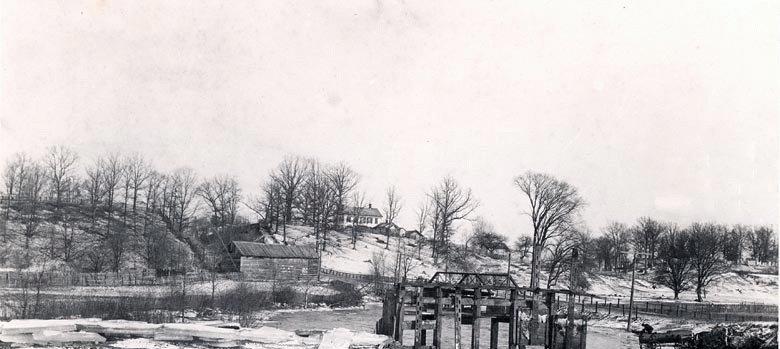
Interestingly, the area almost became two towns. In 1845, Schuyler Haywood of Barnegat, NJ built a flour mill on the west side of the Saline River. Other settlers soon added a saw mill, blacksmith shop, cooper shop, stores and a windmill factory. For a time, local residents considered platting under the name Barnegat. Eventually, however, the west side of the river became Haywood's addition to the Village of Saline. This was in 1848.
In the Beginning
History books record evidence of prehistoric animals in this part of Michigan. In recent years, an archeological dig took place west of our town, where significant finds occurred, revealing mastodon bones and footprints. These are now preserved at the University of Michigan Natural History Museum.
Long before white men came into the area we call Saline, the surroundings were widely known to Native Americans. For generations, they had been canoeing from Lake Erie or using six different trails to reach this area, rich in wildlife and salt. They came to hunt and to acquire salt, which they carried back to their villages for both domestic use and trade. This goes back many generations, even before the name Saline was given to the river by French explorers.
Did Saline Miss Its Moment in History?
In 1823, the University of Michigan appointed two members to inspect various tracts of land in southeast Michigan. They identified four tracts, one of which on the Saline River. At that time, the inspectors were not able to identify the section number. They claimed "the area was destitute of timber and possessed no peculiar advantages". They reported "a valuable salt spring and the trail leading from Detroit to Chicago (that) passed immediately by it." The University said thanks, but no thanks, and looked instead at a salt spring section on the River Rouge in lieu of the one in Washtenaw. (Michigan University Records 1817-37). Had the university decided upon Saline, perhaps we would have become the county seat! This reference appears to be the earliest public record containing a description of land that comprises our City of Saline.
The Start of Settlement
About this same time, Orange Risdon was attracted to this part of the Territory of Michigan while surveying a military road from Detroit to Chicago. He was working at the request of the federal government. The road was subsequently known as the Chicago Road, later called U.S. 12 or Michigan Ave.
Risdon produced The 1825 Map of the Surveyed Part of the Territory of Michigan, which "was the first to show how the land in the southeastern portion of the future state was divided for settlement. Risdon first had to entice potential clients by overcoming the popular belief that the land was unsuitable for agriculture. In his advertisement in the Detroit Gazette on Sept. 10 of that year, he stated with confidence that the land abounds with a most fertile and healthy description and the climate is particularly adapted to our eastern constitution and that the tide of immigration has just begun." (Dunnigan)
On April 5, 1825, Risdon purchased 164 acres from the government. In time, he built his house on the land and it was there that the first town meeting was later held. In 1832, Risdon was instrumental in Saline being platted as an unincorporated village, a status that was retained until 1866 when the village incorporated.
Interestingly, the area almost became two towns. In 1845, Schuyler Haywood of Barnegat, NJ built a flour mill on the west side of the Saline River. Other settlers soon added a saw mill, blacksmith shop, cooper shop, stores and a windmill factory. For a time, local residents considered platting under the name Barnegat. Eventually, however, the west side of the river became Haywood's addition to the Village of Saline. This was in 1848.
The Village Begins to Grow
Saline was founded as a village in 1832 and it wasn't long before it grew, both in population and size. It was an important stage-stop on the Chicago Road and the town attracted a number of artisan workshops and mills. But it was actually the railroad that made the village grow. During the Civil War, so many young men were drawn into the ranks of the military that there was a serious labor shortage. This caused local investments in agricultural equipment to more than double during the 1860s.
By the end of the war, farmers were competing in the expanding commercial marketplace. A desire for a reliable and inexpensive means to transport large amounts of staple crops to market prompted 32 citizens to affix their names to a petition calling for money to be raised to invest in Detroit, Hillsdale, and Indiana Railroad stock. Between the farmers and the merchants, who also saw the possibility of advancing their own interests, the money was raised and sufficient stock was purchased so that the locals convinced the railroad to build a line between Ypsilanti and Hillsdale. It was opened for service on July 4, 1870.
Interestingly, the Michigan Supreme Court ruled this investment violated the state constitution and the railroad was obliged to return the money. Just the same, by this time Saline had its railroad. For almost one hundred years it served us well, providing an efficient way to transport apples, wool, logs and livestock, while bringing in the goods that filled the shelves of local stores. A variety of businesses and services sprang up, increasing the strength and breadth of the village. (National Register, pgs. 5-6)
Education of children was a primary concern of settlers. Even before the Union School was established in Saline, the Lodi Academy was begun in 1847 north of town, in the Lodi Twp. This enterprise "proved to be of incalculable benefit to the youth of the vicinity", and had great success; Lodi became famous for its school". Graduates of the academy became adults of professional integrity. Unfortunately, old age caused Prof. Rufus Nutting to cease his efforts after about ten years. (Chapman, p. 1278)
The old system of ungraded schools was used until 1865, when the graded system began. The Union School was built in 1868 on N. Ann Arbor St. at McKay. The first graduating class of this high school had two members. The building itself was an imposing twin-towered Italianate brick building. (Saline Historic District Comm., p. 9)
The 1874 Combination Atlas Map of Washtenaw County records that Saline is "a flourishing village of about 700 inhabitants on the Detroit, Hillsdale and Indiana Railroad. It contains a fine three-story Union school building; churches of the Baptist, Methodist, Presbyterian, and Evangelical Lutheran persuasions; three flouring-mills, two tanneries, a foundry, two hotels, a newspaper, and several stores and shops. It is situated in the midst of a beautiful and well improved farming country. It has a daily mail." (Saline Historic District Comm.)
One example of an outstanding business that flourished is that of the Saline Standard Windmill Manufacturing Co. which was begun in 1875 by J.C. Gross and Brothers. Their windmills had a reputation for excellence. An example of a Saline Standard Windmill is housed inside the upper barn at the Rentschler Farm Museum. For display purposes, this 10' diameter wooden wheel is mounted on a stub mount tower. It can be seen during regular hours when the farm museum is open on Saturdays.
By 1875, Saline was the principal agricultural shipping point in southeastern Michigan, but the volume of freight moving in and out of the depot dwindled by 1900 and Saline became overshadowed by Ann Arbor and Ypsilanti. With that, the railroad began a slow decline.
The picturesque, sleepy town on the old Chicago Road was about to change.
The 20th Century Comes and Goes
As the turn of the century loomed on the horizon, an electric interurban trolley line operated between Detroit, Ann Arbor, and Jackson. Saline's car, known as Old Maude made frequent trips on rails that ran parallel to Michigan Avenue, connecting with the main line at Ypsilanti. Old Maud made trips "into the city" possible and provided young people studying at the Ypsilanti Normal School with transportation between home and school. The trolley operated about 25 years and was powered by a transformer, whose tower building is long gone.
Development of both automobiles and the trucking industry reduced travel by train and trolley. Rail passenger service to Saline was discontinued in the late 1930s; freight service hung on until the early 1960s.
In spite of the beginnings of the depression, Saline continued to upgrade herself. The Old Union School was torn down in 1930 and a new Art Deco building was constructed on the same site and used the same name.
The following year, the Village of Saline became the City of Saline. That was 1931. Becoming a city gave relief to voters who otherwise would need to travel on Election Day to polling places in several different townships.
The Saline area remained a farming community throughout the 20th century. There was little money to be seen during depression years, but the heavy blows of the times did not affect Saline as greatly as it affected people in the larger cities of our nation. Farmers had always been self-sufficient; there was always food for the table. Add that to the frugalness of Germans and Englishmen and one could observe families who knew how to "make do" with what they had on hand.
The Saline Valley Farms, a farm cooperative on nearly 1000 acres, 3 miles south of town, was begun by Harold S. Gray in 1932. Oral historian James Cameron has written, "(The venture) attracted struggling families during depression years. Over one hundred members lived with their families on site and worked cooperatively to operate a dairy, orchards, poultry house, and gardens. Success mushroomed as members developed a store at the farm to sell to the public and used delivery vans to bring fresh produce and canned goods to Detroit and the suburbs. By the mid-1950s, with the death of the cooperative's founder and a recovering economy and job market, second generation members of SVF families were attracted to life other than farming." It should be noted that most of the residents came to SVF from outside the Saline area, but many these families opted to remain in our area after the Valley Farms closed down. (Cameron)
During World War II, some of Saline's young women went to work in what was termed the "Bomber Plant". Henry Ford had constructed and was operating a huge plant at Willow Run, where airplanes were produced for the government. Breaking into what was normally thought of as a man's world, these women worked side by side, doing whatever job was necessary. Collectively, they were known as Rosie the Riveter. Many of these women had husbands or other relatives in the military and this was their way of helping the war effort and, at the same time, earning money to keep their homes together. Though not on the same pay scale as men, these women earned good wages and life was never the same after that experience.
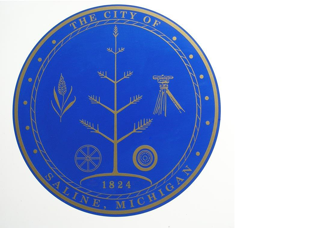
The City Seal
In 1966, thirty-five years after Saline became a city; the seal was adopted and has not changed. The seal symbolizes the elements from which Saline developed into the City it is today: wheat, representing the farmer; the transit, a tool used by Risdon in his work; the automotive wheel, representing a major source of employment for Saline's citizens; a wagon wheel, denoting Saline's early days as a hub in Detroit-Chicago shipping; and in the center, a tree representing the harmonious growth of both agriculture and industry. Encircling the elements is a rope to symbolize the band of strength and character that the city draws from its citizens.
As the Bi-Centennial Year of our nation approached, so did concerns for preserving history. The Historic District Commission was born and charged with duties and functions aimed at identifying and preserving historic buildings within the City of Saline. It took great effort to plan, fund, and execute these goals for zones, which would eventually be designated local historic districts.
With the help of volunteers, as well as paid professionals, the commission identified 335 structures built between the 1820s and 1926. An understanding of the value of preservation and the quality of existing architecture was the main focus of the project.
In the final decade of the century, the Saline Area Historical Society leased two properties from the City and started the area's two museums. The Saline Railroad Depot Museum opened on the 4th of July, 1995, the 125th anniversary of the original opening of the depot. The Rentschler Farm Museum opened to the public on May 8, 1999.
In the 21st Century
The City of Saline is located on US-12, about 35 miles west of Detroit. Michigan Avenue and Ann Arbor Street bisect the downtown area to create the main intersection. The City, itself covers 4.14 sq. miles and is surrounded with vibrant townships that add to the ambiance of the area. A recent Saline Area Directory advises, "Saline continues to be a thriving community at the dawn of the new millennium. Known for its open rural vistas and small town atmosphere, Saline also boasts of well-maintained historic homes that merge into areas of well-groomed contemporary homes."
With a population of just under 10,000 in 2005, Saline prides itself on community involvement. Our schools, churches, district library, hospital, parks and recreation, arts, and museums offer something for everyone. Housing and employment opportunities draw new families to the area daily. Together with the surrounding townships, this is one busy community. (Chamber of Commerce)
Thoughts concerning today's Saline can be expressed in the same words used by Orange Risdon in his 1840 address, "May she continue to shine in light, knowledge and liberty with the same increasing brilliance that she has shown from infancy to the present time".
Sources
- Cameron, James K. Voices Over the Valley, an Oral History of the Saline Valley Farms 1932-1953, publ. by Barnegat Publishing 2004; available through the Saline Area Historical Society Gift Shop
- [See Gift Shop].
- Chapman, Charles C. History of Washtenaw County, publ. by Chapman & Co., Chicago, 1881.
- Dikeman, Agnes L., Celebrating Our Heritage, publ. by Saline Area Historical Society, : 2003.
- Dunnigan, Brian Leigh, "The First Thing Necessary to an Emigrant", The Quarto, Clements Library, University of Michigan, : 2000; one-time permission to copy granted by Brian L. Dunnigan.
- National Register of Historic Places, Application for Saline Railroad Depot, U.S. Dept. of Interior; pgs. 5-6.
- Saline Area Chamber of Commerce Directory, published annually.
- Saline Historic District Commission, Saline Has a Past in Its Future, publ. 1976; available at the Saline District Library, Local History Room
- Michigan University Records 1817-37, Published by the University, 1935; pgs. 88-89.