
Salt Springs
By Robert W. Lane.
November 1819
To most Michigan people, "Cold November" is the time for watching football and celebrating Thanksgiving. It is certainly not for working outside. But, for early 19th century surveyors, it was the best of time. The water table was low, making wet swamps less troublesome. Blood loving Michigan insects that feasted on human flesh were gone. Also, the leaves on bushes and trees had fallen and visibility greatly improved.
In November 1819, Deputy Surveyor Joseph Francis was happy after walking most of the morning in the Michigan Territory, which had a reputation as a swamp wasteland. His survey crew followed him, creating a line using a chain and link, chronometer, transept, hammer, stakes and other surveying equipment. They were marking the boundary line between Sections 1 & 12 of what would be known as Saline Township. He was buoyed by the thought as he finished with this section of Michigan, that he would retire and go home. After four years, he would return to civilized Ohio where surveying made more sense, at least to him. He wanted to help farmers establish boundaries for their land. However today, he would make some remarkable discoveries that always made his work seem useful.
A little before the noon hour, after working his way in the forest, he could see a little clearing through the large oak trees. Since he thought this might be the trail south to Tecumseh and Ohio, he listened and watched carefully. Because of the War of 1812-1815 and the Indian uprising around Monroe, Francis was always cautious in the field. Not seeing or hearing anything, he finally stepped into the path and stood to feel the bare clay ground under his feet. This was certainly the trail, it felt comfortable compared to the leaves, roots, and stones he usually had to walk on.
Since Francis knew a river was north, he explored the trail south for a quarter of a mile and discovered an acre of land cleared of trees. He saw sure signs that caused him to say to himself, "I can't believe it" and he wrote in his personal notes, "This is probably the encampment made during the War (War of 1812) by General William Harrison. When he returned to the working line, he marked the location of the trail in his notebook, where it crossed the section line and continued east, back into the forest. He knew the river and its valley was nearby, east of the trail, and he was alert so as to become aware of it.
After 200 walking feet, the river flood plane came into view and was not what he expected. Using his walking stick, he made his way carefully and found that the soil was turning light in color and that vegetation was thinning. The ground below was shining white in the sun. He stooped so he could touch the whitish soil with his finger, which he placed lightly on his tongue. The taste was salty, just as he suspected. This was another exciting surprise; a salt flat!
A spring had to be nearby and he set about looking for it. He marked his position with a blaze (cut) on a nearby oak and walked the position. There, just south of the line he was working, he found the spring flowing freely at the base of the flood plane, where it met the ridge he had just descended. He observed that this flow was clean water and not full of sulfur, like the springs found east, near Detroit. Those springs formed little yellow volcanoes of sulfur and were not useful. He walked another 200 feet through the white flood plane, his feet sometimes crunching the salt soil and then he rested beside a river to take some lunch. Listening to the river in the quiet, he thought this must be the Saline River and these are the salt springs the French discovered.
After the meal, he carefully recorded information in his survey diary. This would be recorded in the survey map he would draw later. But before he left, he was going to explore this area for his own curiosity. He was sure he would see mounds, like at home in Ohio, local Indian presence, and maybe the salt factory the French from Detroit had here. Joseph Francis and his survey crew were the first people to see and record the Saline salt springs.
After the War of 1812, the federal government wanted to open up this part of the Northwest Territory for settlement and keep it out of the hands of the British, the Indians, and anyone else who might be unfriendly to the young country. Therefore, a rectangular section of Michigan 40 miles west of Detroit was to be surveyed, including the Saline salt springs. A standard contract had been given to Joseph Francis dated 26 May 1819 by the Surveyor General with these orders: "Surveyors are required to make note of (the following): the quality of soil and the situation of all mines, salt licks, salt springs and mill seats which may come to your knowledge and are to be regarded and noticed in your field books." He was instructed to survey this district: Townships Three & Four, east of the Principal Meridian and the Fourth & Fifth Range, south of the Base Line. This area includes Saline and Lodi Townships, today. (SPECIAL INSTRUCTIONS TO DEPUTY SURVEYORS IN MICHIGAN by Prof. R.M. Berry,1990) See map.
Why All This Fuss Over Salt?
In pioneer times, salt was indispensable for preserving meat and tanning hides. In those days, salt was not very common at all, or should I say it was not easy to find salt on the surface. This was not a new problem. The ancient Romans valued salt so much that "sal", their word for salt, became a base for our word, "salary". Citizens of Michigan and Saline had to import salt at great expense, all the way from far-off Kentucky or New York.
Salt and salt springs were always on the mind of early pioneer travelers. Here is a portion of a letter from F.A. Dewey, preserved in the MICHIGAN PIONEER AND HISTORICAL COLLECTION, 1886: From Buffalo to Michigan in 1829: "The third day we were safely landed at the small wharf in Detroit. Thence taking the marked out road, on the line surveyed in the year 1824 called the United States Military Road between Detroit and Chicago, I was led to Ypsilanti, where I found very good fare at the log tavern kept by Mr. Whitmore, thence west through the Saline River near the salt springs, the west side of the river were remaining parts of the military barracks, built by a portion of General Harrison's army in 1814, with a square plot of ground of about one acre, cleared from every grub and stump for parade. Here, in the winter of 1814 and 1815, a regiment was stationed to keep the Indians back."
Dewey was actually coming down today's S. Ann Arbor Street. He turned west where the Fisheries are now, and crossed the Saline River south of the salt springs on one of the Indian trails. Writers like Mr. Dewey were trained to be accurate in school and I trust his observations.
Another longer story tells of Mrs. Chester Parsons and her family coming to Michigan and settling south of the salt springs. Her story is another which will soon appear on our website.
Salt was so important that when Michigan wrote its first Constitution, one of the Articles stated that at least one section of land was to be set aside for each salt spring and to be used as the state thought best. On the L. Petibone Map of 1843, this appears to be the case for Saline. Even later in 1837, Douglas Houghton was asked by the State to make a survey of all the possible locations of salt in Michigan. Houghton discovered over 100 locations. This led to some salt making operations, especially near Saginaw, where there was a supply of wood for fires to remove salt from brine. However, salt production did not reach great size until the opening of mines after 1890.
Salt Production in Saline
During much of the 19th century, salt production was usually profitable at various salt springs. At Syracuse, NY, which had salt springs similar to Saline's, a factory was established using solar power to evaporate water and produce salt. Despite the rather cloudy location, Syracuse became a wealthy center for salt production.
In 1859, the Michigan Legislature passed an Act to aid in the production of more salt in Michigan. It provided that all working salt businesses were exempted from taxes. The Act also allowed for a bounty of 10 cents per bushel of salt, produced after the first 5000 bushels.
In 1863, some Saline entrepreneurs thought that this might be a possibility for Saline. They began a salt production operation. They purchased a lease from John Ruckman for land east of Macon Road, built a wood structure, and laid in pipe to channel the water for dehydration. The story goes that they abandoned the operation in 1866 because they were "paid off" by unknown persons and thus ended Saline's bid for big business. This is probably a true story. At any rate, in 1941, a story appeared in the Saline Observer about a farmer named Finch, who was using his tractor near the Saline River. It fell through the soil into a "cave" and Finch unwittingly discovered an old mining operation with wood beams and an iron pipe. This proves the operation existed.
Salt Geology
To my knowledge, there has never been any research done on the geology of the Saline salt springs and little research at all, on other aspects of the area including history and archeology. My conclusions come from research visits to museums, libraries, scientists, universities and colleges, reading, and walking the area on both private and public property. They are open to change and improvement.
David Westjohn from the United States Geological Survey (USGS) and Corrine Mielko of McMaster University in Canada, Dept. of Environmental Science, volunteered information on ground water. They cannot be sure of the facts concerning our salt springs because of the small amount of information that is available. However, there is probably a salt spur beneath Saline that comes from the large salt deposit below. The massive glacier that covered Saline for thousands of years, as it melted, sent water below that mixed with the salt, forming a salty pool of water. This underground sea was 100 to 200 feet below and was saltier than the ocean. When the glacier finally left Saline, the salt springs immediately began flowing.
What made the salt water flow at Saline? By itself, salt water needed an outside power to send it to the ground surface. These authorities, as mentioned above, say that ancient fresh underground water moves into the area of the salt and mixes with it overtime. As the water table rises, the salt water comes to the surface in the form of a spring. The source of Michigan underground water comes from the middle of the Lower Peninsula, where the underground water travels slowly south. This is very "old water" and needs to be replenished.
It appears that the springs were active well into the 20th century. According to Ray Alber, an old time Saline resident recently deceased, a farmer named Barr lived on S. Ann Arbor Street. Mr. Barr said he could never grow anything on his farmland near the Saline River. This suggests that there was either salt in the soil or some spring activity in the area. A 1907 map at the University of Michigan Map Room shows a spring active near the section line mentioned above.
Corrine Mielko has given me pictures she made in Canada, where a salt spring is active in Wood Buffalo National Park, Northwest Territory. It has crusty salt on the surface. This was broken into chunks and picked up by native and ancient people. There are salt loving plants growing in the area. These conditions are very similar to the Saline springs.
So Are the Springs Still There Today?
The author and others listed below have taken several expeditions to the area in question. We walked the east and west sides of the Saline River from The Fisheries to the Sewer Plant. We used metal detectors on the land that is thought to have been used for the salt factory, as well as to search for General Harrison's encampment. Results are spotty, but we have learned of the location of mounds and also found possible sites for springs, where it might be useful to check for salinity. I walked the section line surveyed by Francis 185 years ago. Through the help of Todd Shelly of Atwell-Hicks, a well known survey company, I was able to understand the way Joseph Francis used links and chains and I believe I found the location of the salt springs of 1819.
It is easy to understand why the springs are not seen today, as the lowering of the ground water table has eliminated the engine that powered the salt springs. The USGS says that the Wayne County water table has dropped 10-15 feet from 19th century levels and likely, some lowering has also occurred in the Saline area of Washtenaw County. There has been much disturbance of land, especially at the Fisheries, where a private company started a fish hatchery business after the closing of the York Mill in the 1940s. However, the salty sea is still there, some 200 feet below the surface of Saline.
The Future
At the south end of Saline's Wilderness Park is an opening looking west over the pond. To the left, is a 20th century power line tower and in front of that is Saline-Milan Road. Over the last 12,000 years, this view encompassed salt springs, Indian mounds, the Sauk Trail, a stage coach road, taverns and inns owned by early settlers, the York Mill and Saline's first horse race track. If you were at this spot in 1819, you would have seen Joseph Francis and his survey crew walk past you.
In conclusion, it is important for private owners, the City of Saline, and the State of Michigan to respect this land over which they have control. Much land alteration has occurred over the years on both sides of the Saline River. This is an area rich in history and archeology. There is no doubt in the minds of experts that more research will generate significant archaeology and history. The salt flats likely had human habitation and extinct animals (i.e., mastodons, mammoths, and saber-toothed tigers) used the salt spring area for over 10,000 years. This should be considered sacred ground.
See also: Michigan Salt, Salt Seeps, and Mastodons on the Pittsfield Township Historical Society website.
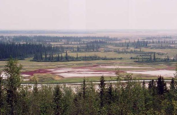
Picture of a salt spring taken in 2004 by Corrine Meilko of McMaster University in Hamilton ON Canada; picture shot in Wood Buffalo National Park, NWT. This area shares many similarities with Saline Salt Spring before the arrival of Europeans.
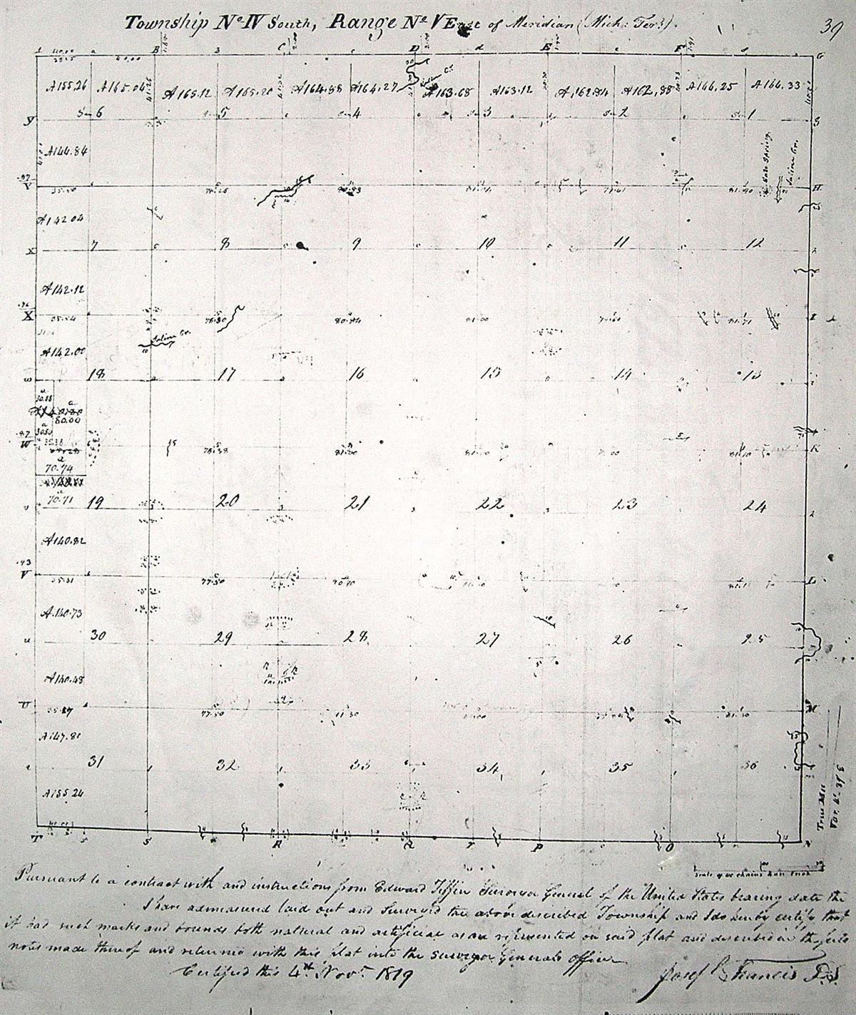
Map drawn by Joseph Francis of what would become Saline Township. The first shows the entire Township.
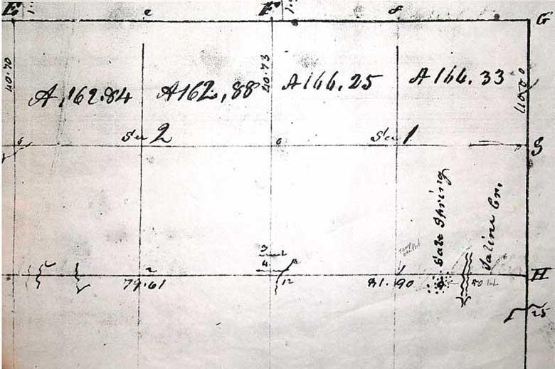
The second map shows sections 1 & 12, only, noting the location of the salt spring. Maps are from the Michigan Historical Museum in Lansing.

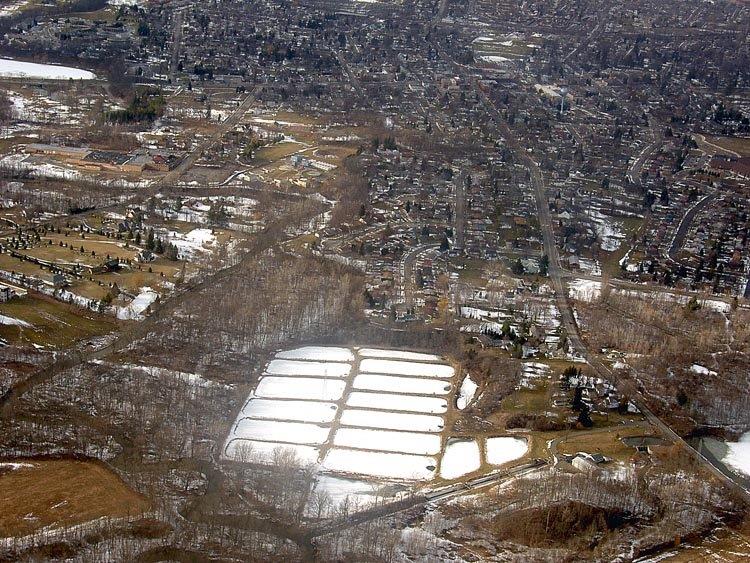
In the foreground, the snow-covered Fishery Ponds can be seen. To the north and west of the ponds is the salt springs area, as it appears today. Arial photo by Bob Lane; courtesy. Matt Lane, plot.l